
What does El Niño mean for Nome and the region?
By Rick Thoman
Alaska Climate Specialist
Alaska Center for Climate Assessment and Preparedness
International Arctic Research Center/University of Alaska Fairbanks
All indications are that El Niño is developing quickly in the deep tropical Pacific Ocean. While there’s been a lot of media hype about a “super El Niño” coming, even if that were to happen —and it's by no means certain— that would not occur until late fall or early winter.
For June through August, NOAA has high odds for a weak to moderate strength El Niño.
So, what does this mean for Alaska overall and Nome specifically? Looking back at the 13 summers since 1970 when El Niño was present, across much of the state, most of those summers were warmer than normal. Rainfall totals were not consistent, though a larger area favored below normal than above.
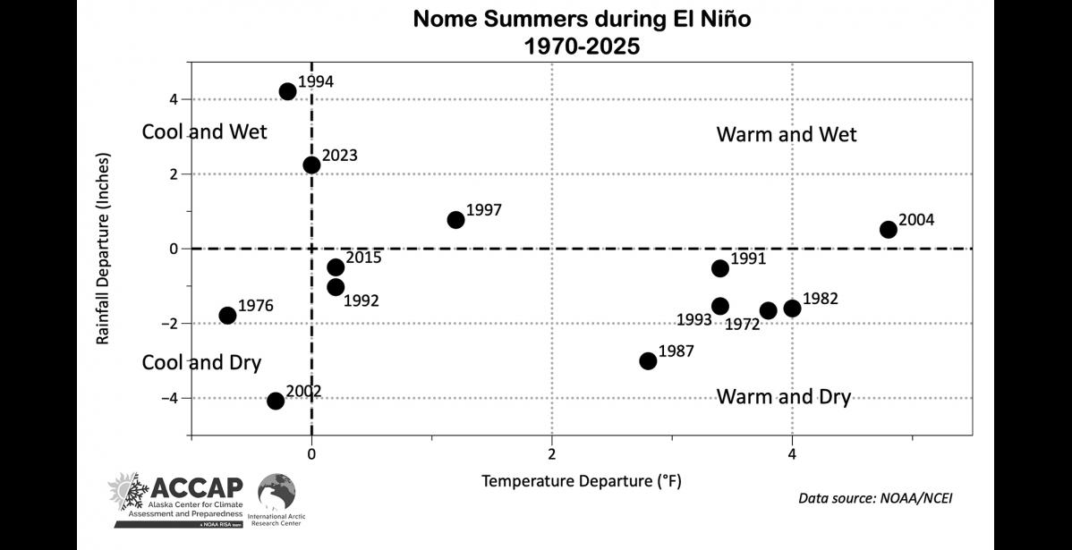
This week's Climate Watch graphic shows how temperatures and rainfall varied at Nome during those El Niño summers. We can divide the results into four possibilities: Summers that were both warmer and wetter than normal; warmer but with less rain than normal; cooler and wetter; and cooler than drier.
A majority of El Niño summers were warmer and drier than normal, and two others were warmer and a little wetter than normal. Only two were cooler and drier than normal and two a little bit cooler with more rain than normal. Now, this is for the entire summer, so it regularly happens that weeks or even a whole month can be decidedly different than the three-month totals. Still, based on the past 56 years, the deck is stacked to favor above normal temperatures and below normal precipitation for Nome this summer.