

Basics on storm surging and coastal flooding
By Rick Thoman
Alaska Climate Specialist
Alaska Center for Climate Assessment and Preparedness
International Arctic Research Center/University of Alaska Fairbanks
Autumn is here so it’s a good time review some basics of storm surge and coastal flooding. Many folks in the region use apps like Windy.com to assess upcoming weather risks and this week's Climate Watch is a review of things to keep in mind when coastal flooding is a possibility.
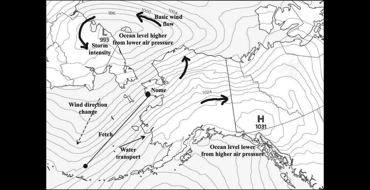
Fetch, the distance winds blow over open water without blockage, matters a lot because winds act as a plow, pushing water up ahead of the wind. The longer the fetch, the bigger the push. Fetch is so important that 500 miles of consistent direction over open ocean regularly produces a greater rise of ocean water level with moderate wind speeds than a 100-mile fetch with much stronger winds.
Air temperature relative to the ocean temperature matters for wind speeds. When the air is colder than the water temperatures, ocean levels and waves will be higher than if the ocean water is colder than the air.
Wind direction is not the same as the water movement. Because of friction and the fact that the earth is rotating, water transport by wind is to the right of the wind. For example, if the wind is blowing straight from the south at Nome, the ocean water transport will be toward Cape Nome.
In eastern Norton Sound, water levels farther to the west, toward the open Bering Sea, matter a lot to ultimate waters levels on the coast when winds turn to the west or southwest. In this case, the change in wind direction allows the higher water already present to slosh eastward (the same effect happens in Kotzebue Sound).
Ocean water level is affected by the atmospheric pressure, with lower pressure resulting in higher water level. This is a direct result of the weight of the air on the ocean surface and happens regardless of winds or tides. The difference in water level just from the difference in pressure between very strong storm compared to normal atmospheric pressure can be a foot or slightly more.
Storms and winds occur independently of the tides, but the timing of the maximum surge of water with the tides can be important in some areas. In our region, the largest difference in the daily tides is over southern Norton Sound. The tidal cycle is much more important for coastal flood impacts on the eastern Bering Sea south of the Yukon River delta.
These are some basic western science guidelines. In every community there are many details that influence how any given storm unfolds. Your experience and Elder's knowledge are critical making the best use of weather forecasts based on computer models.